Harper Area Weather
Current Conditions & Forecasts · Fire Watch · Aviation Weather · Weather Deep Dive
Online since 2012 · Weather archives dating back to 2009 · 1.6+ million weather observations
Weather Deep Dive
Go beyond the basic forecast with current atmospheric
measurements, historical weather, sun and moon data,
station instrumentation and the systems behind the
Harper area weather station.
Station data updated:
02:50 PM · November 20, 2026
Temperature, Humidity & Pressure
Core atmospheric measurements and derived values
Dew Point
52.7°F
Heat Index
68.2°F
Barometric Pressure
29.999 inHg
3-hour change -0.123 inHg
Wind
Current and short-term wind behavior
Current Wind
7 mph
S
(177°)
Current Gust
11 mph
S
10-Minute Average
7 mph
Average wind speed · last 10 minutes
10-Minute Peak
13 mph
Peak gust · last 10 minutes
Since Midnight
20 mph
Peak gust ·
02:01 PM
Past 24 Hours
20 mph
Peak gust ·
Nov 20 · 02:05 PM
Rainfall
Because every hundredth of an inch matters in the Hill Country
Today
0.00 in
Yesterday
0.00 in
Month
2.90 in
Year
32.17 in
Solar & UV
Solar radiation and ultraviolet observations
Solar Radiation
482 W/m²
Strong
Weak
Moderate
Strong
Very Strong
Intense
Current solar irradiance level
UV Index
2.6
—
Low
Moderate
High
Very High
Extreme
Sun exposure risk level
THSW Index
69.7°F
Calculated locally
Sun/wind impact on temperature:
+0.4°F
Historical Weather
Harper station history, trends and climatological summaries
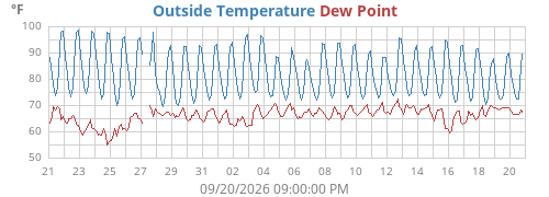
Temperature History
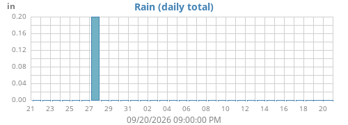
Rainfall History
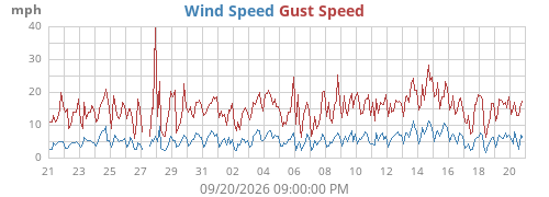
Wind History
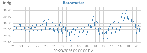
Pressure History
Station Records
Last checked: —
Highest Temperature
—
—
Lowest Temperature
—
—
Lowest Wind Chill
—
—
Highest Wind Gust
—
—
Highest Rain Rate
—
—
Wettest Day
—
—
Wettest Month
—
—
Wettest Year
—
—
Station records based on archived Harper weather observations.
Current Year & Climate Reports
Current-year observations and long-term climatological reports
Current-year highlights are shown below, followed by
monthly and annual reports generated from the Harper
weather archive.
Current Year
YTD High
101.5°F
Aug 27, 2026
YTD Low
11.6°F
Jan 25, 2026
YTD Rain
32.17 in
Through Nov 20
Highest Wind
40 mph
Feb 14, 2026
2009-08
2009-09
2009-10
2009-11
2009-12
2010-01
2010-02
2010-03
2010-04
2010-05
2010-06
2010-07
2010-08
2010-09
2010-10
2010-11
2010-12
2011-01
2011-02
2011-03
2011-04
2011-05
2011-06
2011-07
2011-08
2011-09
2011-10
2011-11
2011-12
2012-01
2012-02
2012-03
2012-04
2012-05
2012-06
2012-07
2012-08
2012-09
2012-10
2012-11
2012-12
2013-01
2013-02
2013-03
2013-04
2013-05
2013-06
2013-07
2013-08
2013-09
2013-10
2013-11
2013-12
2014-01
2014-02
2014-03
2014-04
2014-05
2014-06
2014-07
2014-08
2014-09
2014-10
2014-11
2014-12
2015-01
2015-02
2015-03
2015-04
2015-05
2015-06
2015-07
2015-08
2015-09
2015-10
2015-11
2015-12
2016-01
2016-02
2016-03
2016-04
2016-05
2016-06
2016-07
2016-08
2016-09
2016-10
2016-11
2016-12
2017-01
2017-02
2017-03
2017-04
2017-05
2017-06
2017-07
2017-08
2017-09
2017-10
2017-11
2017-12
2018-01
2018-02
2018-03
2018-04
2018-05
2018-06
2018-07
2018-08
2018-09
2018-10
2018-11
2018-12
2019-01
2019-02
2019-03
2019-04
2019-05
2019-06
2019-07
2019-08
2019-09
2019-10
2019-11
2019-12
2020-01
2020-02
2020-03
2020-04
2020-05
2020-06
2020-07
2020-08
2020-09
2020-10
2020-11
2020-12
2021-01
2021-02
2021-03
2021-04
2021-05
2021-06
2021-07
2021-08
2021-09
2021-10
2021-11
2021-12
2022-01
2022-02
2022-03
2022-04
2022-05
2022-06
2022-07
2022-08
2022-09
2022-10
2022-11
2022-12
2023-01
2023-02
2023-03
2023-04
2023-05
2023-06
2023-07
2023-08
2023-09
2023-10
2023-11
2023-12
2024-01
2024-02
2024-03
2024-04
2024-05
2024-06
2024-07
2024-08
2024-09
2024-10
2024-11
2024-12
2025-01
2025-02
2025-03
2025-04
2025-05
2025-06
2025-07
2025-08
2025-09
2025-10
2025-11
2025-12
2026-01
2026-02
2026-03
2026-04
2026-05
2026-06
2026-07
2026-08
2026-09
2026-10
2026-11
Climatological Report Archive
Select a month for the complete daily report
Loading climatological archive…
Earlier Years
Sun & Moon Almanac
Solar and lunar events calculated for the Harper weather stationSun
Start Civil Twilight
06:40:49 AM
Sunrise
07:06:55 AM
Solar Noon
12:23:00 PM
Sunset
05:38:49 PM
End Civil Twilight
06:04:55 PM
Azimuth
219.9°
Altitude
28.7°
Declination
-19.8°
Next Equinox
03/20/2027 03:24:32 PM
Next Solstice
12/21/2026 02:49:59 PM
Moon
Moonrise
02:48:10 PM
Transit
09:15:01 PM
Moonset
02:48:29 AM
Azimuth
82.8°
Altitude
0.1°
Declination
6.0°
Phase
Waxing gibbous
Illumination
82% full
Next New Moon
12/08/2026 06:51:46 PM
Next Full Moon
11/24/2026 08:53:29 AM
Instrumentation
The instruments and sensors behind the observations
Weather Receiver
WeatherLink Live
Local network acquisition
Network Switch Temperature:
77.6°F
Network Switch Humidity:
41%
Wind
Davis Vantage Pro2
Transmitter 1
Battery: OK
Temperature / Humidity / Rain
Davis Vantage Pro2
Transmitter 2
Battery: OK
Weather Software
WeeWX 5.5.2
Harper weather server
Custom design by John Canfield
Coding assistance by ChatGPT
Custom design by John Canfield
Coding assistance by ChatGPT
Station Details
Weather server, software, telemetry and the details only a true weather geek could love
Weather Server Uptime
—
CPU Temperature
—
WeeWX Service Uptime
—
System Load
—
Disk Space Available
—
Last Weather Archive
—
Current Distance to Mars
—